How Much At Risk Are Alaska Waters If New Drilling Plan Goes Through
As the Trump administration’s platform of Drill, Baby Drill takes shape, new models suggest how coastal areas, including in Alaska could be affected by oil spills. Here’s some reaction from ARC Initiatives
Ahead of Comment Period Close, Newly Released Models Reveal Trump’s Offshore Drilling Plan Could Threaten Coasts with Massive Oil Spills
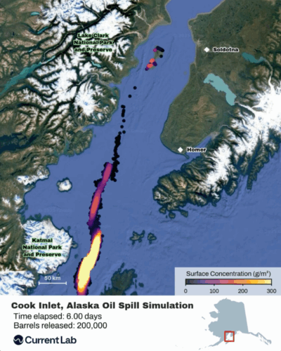
(Washington, DC) – New models (video simulations available at the link) conducted by Current Lab reveal how ocean currents can carry oil far from spill sites in a matter of days. Physical oceanographers simulated the spread of surface oil film over several days at three sites identified as vulnerable to oil spills from the Trump administration’s proposed National Outer Continental Shelf Oil and Gas Leasing Program (Five-Year Plan).
“I responded to oil spills for decades. We’re no longer ready for a big one. Once oil is spilled into the ocean, it begins to spread and move rapidly – making effective modeling and fully-staffed agencies essential for protecting sensitive shorelines, maximizing oil recovery, and minimizing environmental damage. But with the Trump Administration’s drastic changes to the federal government, while proposing to vastly expand offshore oil and gas leasing, we are facing an extremely dangerous combination that will result in disaster. Our leaders must fully consider the consequences before moving this new offshore leasing plan forward,” – Doug Helton, the former regional operations supervisor in the National Ocean Services Office of Response and Restoration at the National Oceanic and Atmospheric Administration.
The visuals show how ocean currents and wind could transport oil across Florida, California, and Alaska. They incorporate publicly-available regional ocean circulation models for each scenario, along with wind data from NOAA’s Global Forecast System. While the oil release rates and densities reflect values estimated in Worst Case Discharge Scenarios from the federal government’s Bureau of Safety and Environmental Enforcement (BSEE) or regional contingency plans created by local governments, the visuals are not predictions of spill size or magnitude at these locations. The models also show only the initial spread of oil over several days.
The Florida model is particularly impressive, finding that oil would slam Cuba and wrap around the Florida peninsula, washing up on Miami’s beaches and even reaching West Palm Beach — putting risk in the backyard of Trump’s Mar-a-Lago club.
BSEE acknowledges that spills off the coasts of Florida and California could last over 100 days, releasing tens of millions of barrels of oil. These visuals represent only a small fraction of the government’s estimated Worst Case Discharge Scenarios, but provide important context for how quickly ocean currents can move oil away from spill sites and underscore the significant risk posed by new proposed leasing and offshore drilling.
Additional Information
President Trump’s Interior Department recently released an offshore drilling plan that proposes 34 oil and gas lease sales in the Gulf of Mexico, Alaska, and California. This offshore drilling plan includes areas where oil and gas drilling has never happened before and places where lease sales have not been held for decades.
These models offer a powerful, data-driven way to localize the high-stakes debate over the administration’s plan, which is currently undergoing a public comment period that closes tomorrow, January 23rd.

Alaska Salmon 2011: Not Too Shabby

Prime Time For Face Time At Sportsmen’s Shows